Q’Rith: Maps and World-Building
.I started the process of building the world of Q’Rith, and the nature and politics of the area of it my campaign would be focused on, conceptually rather than visually, which is to say: I didn’t have a map.
I had a strong sense of how it was supposed to work in terms of the dynamics between regions, what the scale should be like, and of pieces of the history of the region. I also knew it would start on the east coast of a large continent, and that the continent’s dominant state would stretch from one coast to the other. But that was more or less all.
Eventually I had to sketch out a map, which I believe I did using The GIMP. Drawing is not at all a skill of mine, even with the help software can give me, and this map looked quite awful. It was enough, however, to let me lay out roughly where things were and how they related to each other, that latter being completely critical for an understanding of how the world would actually function.
I kept playing with that map for a while, and then switched over to Inkscape, primarily because vector graphics allow the possibility of being able to use the same base map at entirely different scales. It still looked appalling, like something an untalented child might scribble on the back of a school notepad.
I had managed to come up with a reasonable map for the starting city, Anaq’rest, but cities are regular constructions in many ways, and as such far easier to build using regular shapes. Since the players were in the same city for the entire first season, I didn’t have to worry about the larger world map much. However, in the second season they’re likely to travel widely, and for that I needed reasonable maps. Worse, I would probably need maps that I could show the players without eliciting laughter (or pity).
I spent a fair amount of time on the continental map I had this weekend, including segmenting it out by country and developing the previously-unmapped northern and southern reaches of the continent. At the end of these efforts, I realized that while the map made sense to me in terms of the relationships between the elements on it, it still looks like an abandoned child’s drawing. And this after I put a fair amount of effort into trying to make it look better.
The main problem with it was that it just didn’t look realistic; the shapes were wrong, somehow, but knowing this didn’t help me get them right. Therefore, it was time to cheat.
There are plenty of real-world maps available online, Google Maps being only the most obvious. I wasn’t going to use real-world maps as they were, because that would be too distracting. I also couldn’t go find someone else’s decent fantasy world map and use that, because the shape of mine was already fairly set. So I grabbed bits of existing real-world geography and jammed them together into a shape not far from my original, but which looks rather better:
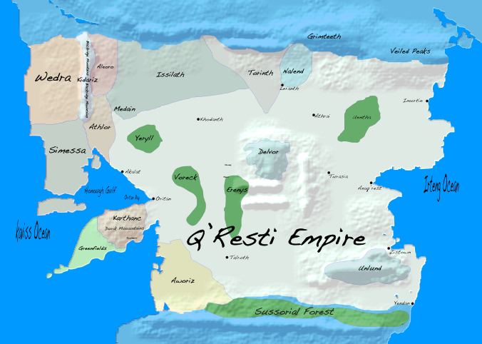
The whole continent, Garlathia, is about 6500km north–south and about 4000km east–west. At the moment, though, the campaign is only concerned with the central area, about 2000km north–south and 3000km east–west:
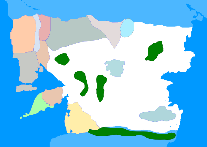
The large white area is the dominant state (the Q’Resti Empire), the green areas are forests not under the control of that state, and the other colored areas are other countries.
The lack of geographical details makes it somewhat featureless, but even at this point certain likely areas of conflict become clear, such as struggles over sea power in the west. Before creating any map, I knew:
- Q’Rest would have rival powers to the west, and that the previous dominant state, Issilath, would remain large, albeit quiescent.
- A desolate, sparsely-populated, but large northern expanse beyond the Empire was present.
- A major rival would control the southern continent but that geographical limits would make invasion on either side difficult.
- Q’Rest would almost entirely control the eastern seaboard.
- Elven and dwarven nations would exist entirely surrounded by Q’Rest.
Once I started making the map, other details revealed themselves, particularly once I added in details about where e.g. mountains and rivers were. More details came from writing rather than from mapping, for example from an encylopedia-style entry about the Empire that includes a paragraph about all of its neighbors—this guided much of the map work, although it now needs to be adjusted because some of the geography changed during mapping.
I had a lot of trouble making the mountains look in any way acceptable on the map. I didn’t think rivers were likely to be too hard, but I had to get the mountains done first; my original map’s approach of simply using brown rectangles really didn’t cut it. I knew that bump mapping was the right approach, but wanted to keep the details in Inkscape as much as possible—so I was happy to find this post on Inkscape bump mapping. I had to switch between Inkscape and The GIMP a few times to get the look I wanted, but it proved possible.
In doing that I ended up having to shift some countries around to match the now-placed geological foundations, but that was relatively minor.
Before I started the map reworking, I had come up with some answers to basic demographic questions. The Q’Resti Empire has a population of somewhere around 20 million people, of which about 2.25 million reside in towns or cities with over 10,000 inhabitants. There are 50 of those cities, and I determined populations for all of those, as well as names and locations for the top 10:
- Anaq’rest, the capital, 500,000 inhabitants.
- Oritan, “the second capital” or “the Western capital”, 250,000 inhabitants.
- Athrai, “the old capital”, 170,000 inhabitants.
- Turasia, critical river trade and fair town, 120,000 inhabitants.
- Leranth, border post grown into commercial hub, 100,000 inhabitants
- Khodanth, former Issilanth regional capital, 85,000 inhabitants.
- Talroth, formerly Silvotia City, still being rebuilt, 70,000 inhabitants.
- Akalat, secondary port in the Honough Gulf, 60,000 inhabitants.
- Imortin, key port for northern hunting/mining commerce, 55,000 inhabitants.
- Yendan, a garrison port the Empire is trying hard to grow, 50,000 inhabitants.
I also finalized a location for the important city of Zistown, a large (350,000 inhabitants), purported “free city” caught in a struggle between its citizens, the acquisitive Q’Resti Empire, and the dwarven nation of Unlund, who helped found Zistown and who want to keep it an open, low-fee port for their commerce.
With borders, acceptable mountains, and major city locations, it’s in good enough shape to share; a lot of forests (not to mention marshes, bogs, deserts, and lakes) are still missing. As are the rivers, but I already know where most of them run.